第 1 單元,第 1 課
Why is geography a science?地理學為什麼是一門科學?
這課一眼看
Welcome to geography認識地理學
- geography地理學: The study of where things are on Earth and why.
- place地方: A specific point on Earth with its own character.
- region區域: An area defined by one or more shared features.
- scale尺度: How much of Earth is studied compared with the whole.
- space空間: The physical gap between objects.
- connection連結: Relationships among people and things across space.
Contemporary geographic tools現代地理工具
- map地圖: A flat, scaled-down model of Earth’s surface.
- cartography地圖學: The science of making maps.
- geographic information system地理資訊系統(GIS): A computer system that stores, analyzes, and maps geographic data in layers.
- remote sensing遙測: Collecting data about Earth from a distance, e.g., by satellite.
- Global Positioning System全球定位系統(GPS): A satellite system that finds exact positions on Earth.
- geotagging地理標記: Storing information with its exact latitude and longitude.
- volunteered geographic information志願地理資訊(VGI): Map data created and shared for free by ordinary people.
The geographic grid地理座標
- geographic grid地理座標(經緯網): The system of meridians and parallels used to find locations.
- meridian經線: A line from the North Pole to the South Pole.
- longitude經度: The numbering system for meridians, 0°–180° E or W.
- parallel緯線: A circle around Earth parallel to the equator.
- latitude緯度: The numbering system for parallels, 0°–90° N or S.
- prime meridian本初子午線: The 0° meridian, through Greenwich, England.
- International Date Line國際換日線: A line near 180° where the calendar date changes.
- map scale比例尺: The relationship between map distance and real distance.
- projection投影: A method of drawing the round Earth on a flat map.
1Welcome to geography認識地理學
AFive basic concepts of geography地理學的五個基本概念
- geography is the study of where things are found on Earth’s surface and why they are there. Human geographers ask two questions about people and their activities: Where are they? Why are they there?地理學研究事物分布在地表的哪裡,以及為什麼會在那裡。人文地理學家針對人類與人類活動問兩個問題:在哪裡?為什麼在那裡?
- Geographers use five basic concepts. A place is a specific point on Earth with its own character. A region is an area defined by one or more shared features. scale is how much of Earth is being studied compared with the whole Earth. space is the gap between objects. connection is the relationship among people and things across space.地理學家使用五個基本概念。地方是地表上具有自身特色的特定地點;區域是由一個或多個共同特徵界定的範圍;尺度是所研究的範圍和整個地球相比的大小;空間是物體之間的間距;連結是人與事物跨越空間的關係。
Geography’s five basic concepts地理學的五個基本概念
| Concept概念 | Meaning意義 | Example例子 |
|---|---|---|
| Place地方 | a specific point with its own character有自己特色的特定地點 | your hometown你的家鄉 |
| Region區域 | an area with shared features具有共同特徵的地區 | Southeast Asia東南亞 |
| Scale尺度 | how much of Earth is studied研究地球的範圍有多大 | local, national, global地方、國家、全球 |
| Space空間 | the gap between objects物體之間的間隔 | how far apart stores are商店彼此相隔多遠 |
| Connection連結 | links among people and places人與地方之間的關聯 | trade, migration, the internet貿易、遷移、網路 |
BGeography and history地理學與歷史學
- Geography and history both collect evidence about human activity, but they organize it differently. Historians arrange events in order of time and ask when and why. Geographers arrange features across space and ask where and why.地理學和歷史學都蒐集人類活動的證據,但整理方式不同。歷史學家依時間排列事件,問「何時」與「為什麼」;地理學家依空間排列現象,問「哪裡」與「為什麼」。
- An action in one place can cause changes somewhere else, just as an event in the past can affect the future. One difference is that a geographer can actually travel to the places being studied, but a historian cannot travel back in time.某地的行動可能造成另一地的改變,就像過去的事件會影響未來一樣。不同的是,地理學家可以親自前往研究的地方,歷史學家卻無法回到過去。
Geography vs. history地理學 vs. 歷史學
| Geography地理學 | History歷史學 | |
|---|---|---|
| Organizes evidence by整理證據的依據 | space (where)空間(在哪裡) | time (when)時間(何時) |
| Key question核心問題 | Where and why?在哪裡?為什麼? | When and why?何時?為什麼? |
| Can visit what it studies?能親自到研究對象嗎? | yes, by traveling to places能,可以前往當地 | no, the past cannot be visited不能,無法回到過去 |
2Contemporary geographic tools現代地理工具
AMaps, GIS, and remote sensing地圖、GIS 與遙測
- A map is a flat, scaled-down model of all or part of Earth’s surface. Maps work as reference tools (finding a route) and as communication tools (showing how something is distributed). The science of making maps is cartography.地圖是把全部或部分地表縮小後畫在平面上的模型。地圖可以當參考工具(找路線),也可以當溝通工具(呈現事物的分布)。製作地圖的科學稱為地圖學。
- A geographic information system (GIS) captures, stores, analyzes, and displays geographic data. Each type of data is kept in its own layer, such as roads, rivers, or country borders, and layers can be combined to look for relationships.地理資訊系統(GIS)用來擷取、儲存、分析和呈現地理資料。每一類資料放在獨立的圖層,例如道路、河流或國界,圖層可以疊合起來找出彼此的關係。
- remote sensing collects data about Earth’s surface from a distance, using sensors on satellites, airplanes, or drones. Measuring Earth’s surface from photographs is called photogrammetry. These tools let geographers make accurate maps and track changes over time.遙測是利用衛星、飛機或無人機上的感測器,從遠處蒐集地表資料。從照片測量地表則稱為航空攝影測量。這些工具讓地理學家能畫出精確的地圖,並追蹤地表隨時間的變化。
BGPS and volunteered mapsGPS 與志願地理資訊
- The Global Positioning System (GPS) uses a network of satellites and receivers to find the exact position of something on Earth. It is used mainly for navigation by drivers, pilots, and ships. Storing a photo or post together with its exact latitude and longitude is called geotagging.全球定位系統(GPS)利用衛星網和接收器找出地表上物體的精確位置,主要用於駕駛、飛行員和船隻導航。把照片或貼文連同精確經緯度一起儲存,稱為地理標記。
- volunteered geographic information (VGI) is map data that ordinary people create and share for free. OpenStreetMap is a free world map built by volunteers, and humanitarian mapping teams use it to guide disaster response. VGI is one kind of citizen science, research carried out by amateurs.志願地理資訊(VGI)是一般民眾自願、免費製作並分享的地圖資料。OpenStreetMap 是由志工共同建立的免費世界地圖,人道救援製圖團隊會用它來協助救災。VGI 是公民科學的一種,也就是由業餘者進行的研究。
Contemporary geographic tools當代地理工具
| Tool工具 | What it does功能 | Example use用途舉例 |
|---|---|---|
| Map地圖 | a flat, scaled-down model of Earth’s surface地表的平面縮小模型 | finding a route找路線 |
| GIS地理資訊系統(GIS) | stores data in layers and combines them以圖層儲存並疊合資料 | overlaying roads and rivers疊合道路與河流 |
| Remote sensing遙測 | collects data from satellites, planes, or drones以衛星、飛機或無人機蒐集資料 | tracking forest loss追蹤森林消失 |
| GPS全球定位系統(GPS) | finds an exact position with satellites以衛星找出精確位置 | car navigation汽車導航 |
| VGI自發性地理資訊(VGI) | map data made and shared by ordinary people一般民眾製作並分享的地圖資料 | OpenStreetMap for disaster response用 OpenStreetMap 協助救災 |
自我檢查
How is a GIS different from GPS?GIS 和 GPS 有什麼不同?
看答案
GPS finds the exact location of something. A GIS stores and analyzes many layers of geographic data and turns them into maps.GPS 用來找出某物的精確位置;GIS 則儲存、分析多個圖層的地理資料,並把它們製成地圖。
3Making maps製作地圖
AThe history of mapmaking地圖學的歷史
- Geography grew up in the ancient world. Greek scholars argued that Earth is a sphere, and Eratosthenes, who invented the word geography, estimated Earth’s circumference with great accuracy. Ptolemy later wrote a long guide to geography with maps of the known world. Early Chinese writers also described the land and resources of their country.地理學起源於古代。希臘學者主張地球是球體;創造「地理學」一詞的埃拉托斯特尼相當準確地估算出地球周長。後來托勒密寫成一部附有已知世界地圖的地理學鉅著。古代中國的著作也記錄了國內的土地與資源。
- After Ptolemy, European maps became less accurate for centuries, while other scholars kept improving them. One of them, al-Idrisi, was born in North Africa; in 1154, in Sicily, he made a world map for King Roger II. Accurate maps returned to Europe during the Age of Exploration, when sailors needed them to cross the oceans safely.托勒密之後,歐洲地圖有好幾百年變得不準確,其他學者則持續改進地圖。其中的伊德里西生於北非,1154 年在西西里為國王羅傑二世繪製世界地圖。到了地理大發現時代,航海者需要地圖安全橫越海洋,精確的地圖才重新在歐洲出現。
Milestones in mapmaking製圖史上的里程碑
| Who / when人物/時代 | Contribution貢獻 |
|---|---|
| Ancient Greek scholars古希臘學者 | argued that Earth is a sphere主張地球是球體 |
| Eratosthenes埃拉托斯特尼 | coined the word geography; estimated Earth’s circumference創造 geography 一詞;估算地球周長 |
| Ptolemy托勒密 | wrote a guide to geography with maps of the known world寫下附有已知世界地圖的地理指南 |
| Early Chinese writers早期中國作者 | described China’s land and resources描述中國的土地與資源 |
| al-Idrisi (born in North Africa)伊德里西(生於北非) | kept improving maps while European maps declined; made a world map in Sicily for King Roger II in 1154在歐洲地圖退步時持續改進地圖;1154 年在西西里為國王羅傑二世繪製世界地圖 |
| Age of Exploration大航海時代 | accurate maps returned to Europe for ocean travel為了航海,精確地圖回到歐洲 |
BTypes of thematic maps主題地圖的種類
- Maps can show data in several ways. Choosing the right type makes a pattern easy to see.地圖可以用多種方式呈現資料,選對類型才能讓分布模式一目了然。
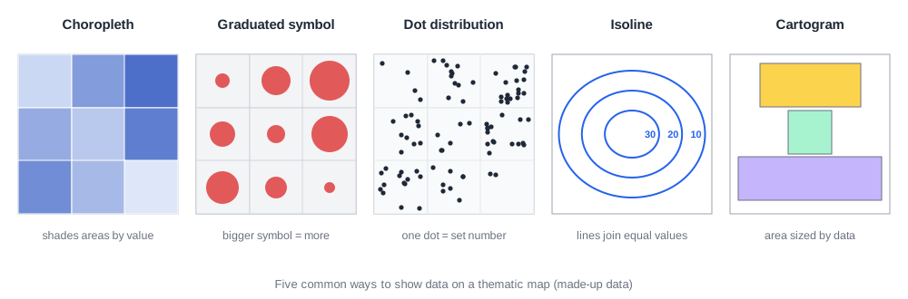
Ways to show data on a map在地圖上呈現資料的方式
| Map type地圖類型 | How it shows data如何呈現資料 | Reading tip判讀訣竅 |
|---|---|---|
| Choropleth map面量圖 | shades whole areas by value依數值為整個區域上色 | darker = higher value顏色越深=數值越高 |
| Graduated symbol map等級符號圖 | symbols change size符號大小隨數值改變 | bigger symbol = higher value符號越大=數值越高 |
| Dot distribution map點描圖 | each dot stands for a set number每個點代表固定數量 | many dots = clustered點越密=越集中 |
| Isoline map等值線圖 | lines join places with equal values連接數值相等之地的線 | like contour lines像等高線 |
| Cartogram變形地圖 | area size drawn by data value面積依資料數值繪製 | big area = high value面積大=數值高 |
自我檢查
A map shows each U.S. state stretched or shrunk so that its size matches its population. What type of map is it?一張地圖把美國各州放大或縮小,讓面積和人口數成比例。這是哪一種地圖?
看答案
A cartogram, because the size of each area is drawn in proportion to its data value, not its real land area.統計地圖(cartogram),因為各區的大小是按資料數值而不是實際面積畫的。
4The geographic grid地理座標
ALatitude, longitude, and time zones經緯度與時區
- The geographic grid is a system of imaginary lines used to describe any location on Earth. A meridian is a line that runs from the North Pole to the South Pole; its number is the location’s longitude. A parallel is a circle around Earth parallel to the equator; its number is the location’s latitude.地理座標是用來描述地表任一位置的一套假想線。經線是連接南北極的線,它的編號就是該地的經度;緯線是與赤道平行、環繞地球的圓,它的編號就是該地的緯度。
- The prime meridian, which passes through Greenwich, England, is 0° longitude; other meridians are numbered 0°–180° east or west. The equator is 0° latitude; parallels are numbered 0°–90° north or south.通過英國格林威治的本初子午線是經度 0°,其他經線向東或向西編號 0°~180°。赤道是緯度 0°,緯線向北或向南編號 0°~90°。
- Earth turns 360° in 24 hours, so every 15° of longitude equals one hour. This gives 24 time zones. The reference time at 0° is Coordinated Universal Time (UTC). Crossing the International Date Line, near 180°, changes the calendar by one day.地球 24 小時自轉 360°,所以經度每 15° 相差一小時,形成 24 個時區。0° 經線的標準時間是協調世界時(UTC)。越過靠近 180° 的國際換日線,日期會改變一天。
注意
Example: a city at 120° W is 120 ÷ 15 = 8 hours behind UTC.例:位於西經 120° 的城市比 UTC 慢 120 ÷ 15 = 8 小時。
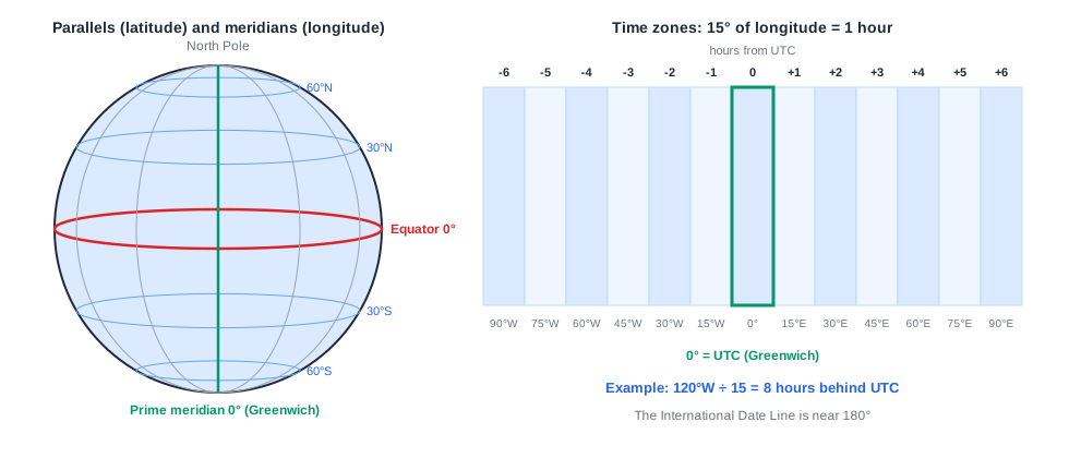
Meridians vs. parallels經線 vs. 緯線
| Meridian經線 | Parallel緯線 | |
|---|---|---|
| Direction方向 | runs from North Pole to South Pole由北極連到南極 | circles Earth parallel to the equator與赤道平行環繞地球 |
| Measures代表 | longitude經度 | latitude緯度 |
| Starting line (0°)起始線(0°) | prime meridian (Greenwich)本初子午線(格林威治) | equator赤道 |
| Range範圍 | 0°–180° east or west東、西經 0°–180° | 0°–90° north or south南、北緯 0°–90° |
自我檢查
Taipei is near 120° E. When it is 12:00 noon UTC, about what time is it in Taipei?台北位於東經約 120°。當 UTC 是中午 12:00 時,台北大約幾點?
看答案
About 8:00 p.m. Places east of the prime meridian are ahead of UTC, and 120 ÷ 15 = 8 hours.大約晚上 8:00。本初子午線以東的地方時間比 UTC 快,120 ÷ 15 = 8 小時。
BMap scale and projection比例尺與投影
- map scale is the relationship between a distance on a map and the real distance on Earth. It can be written as a ratio (1:24,000), in words (“1 centimeter equals 10 kilometers”), or as a graphic bar line.比例尺是地圖上距離與地表實際距離的關係,可以用比例(1:24,000)、文字(「1 公分代表 10 公里」)或線段比例尺表示。
- A map of a small area can show a lot of detail; a map of the whole world must leave most details out.小範圍的地圖可以呈現很多細節;整個世界的地圖則必須省略大部分細節。
- projection is the method of moving locations on a round Earth onto a flat map. Every projection distorts something: shape, distance, relative size, or direction. The Mercator projection keeps shapes but makes areas near the poles look far too large; equal-area projections keep sizes correct but stretch shapes.投影是把球面上的位置轉移到平面地圖上的方法。每一種投影都會扭曲某些東西:形狀、距離、相對大小或方向。麥卡托投影保持形狀,卻讓高緯地區看起來過大;等積投影保持面積正確,卻會拉長形狀。
Three ways to show map scale比例尺的三種表示法
| Form形式 | Example例子 |
|---|---|
| Ratio數字比例 | 1:24,0001:24,000 |
| Words文字敘述 | “1 centimeter equals 10 kilometers”「1 公分等於 10 公里」 |
| Graphic bar線段比例尺 | a line marked in kilometers標有公里刻度的線段 |
這課的重點字
- geography地理學
- place地方
- region區域
- scale尺度
- space空間
- connection連結
- map地圖
- cartography地圖學